Previous Story
Colombia Declares National Disaster After Magnitude 7.4 Earthquake Kills at Least 111
Posted On August 10, 2026
Comment: Off
Tag: abelardo de la espriella, bogotá, cali, chocó, Cruz Roja Colombiana, earthquake Colombia, epm, intermediate-depth earthquake, magnitude 7.4 earthquake, manizales, medellin, Nazca plate, PAGER, pereira, popayan, Puracé, quibdo, San José del Palmar, servicio geológico colombiano, ShakeMap, strike-slip fault, subduction zone, terremoto Colombia, ungrd, USGS, Volcán Puracé
The death toll is certain to climb as rescue teams and citizen groups mobilize to find survivors.
A magnitude 7.4 earthquake struck western Colombia at 7:34 a.m. local time on Monday, August 10, 2026, killing at least 111 people and injuring 87 others, according to figures confirmed by President Abelardo de la Espriella and reported by Noticias Caracol. Twenty-nine of the deaths occurred in capital cities. The figures are expected to rise as search-and-rescue teams continue working through collapsed buildings in Cali, Chocó, and the Coffee Axis region.
“The same seismic systems and plate tectonics powering today’s earthquake are also behind recent volcanic activity at Volcán Puracé, but it would be a mistake without more evidence to infer any causality between the phenomena.” — Isabella Casasbuenas, mining engineer, Universidad Nacional de Colombia
The US Geological Survey (USGS) located the epicenter 5 kilometers south of San José del Palmar, a small municipality in the department of Chocó, at a depth of approximately 110 kilometers. The Servicio Geológico Colombiano (SGC, Colombian Geological Survey) described it as the strongest earthquake to hit Colombia in a decade. It was felt as far away as Bogotá, Medellín, and neighboring Venezuela, Ecuador, and Panama.
The national government declared a “situación de desastre nacional” (national disaster situation), and President de la Espriella, who was inaugurated just three days earlier, canceled his Monday agenda to lead the response personally. “He asumido directamente el liderazgo de la atención por la emergencia en San José del Palmar” (“I have taken direct leadership of the emergency response in San José del Palmar”), the president wrote, announcing a Puesto de Mando Unificado (Unified Command Post) at the Unidad Nacional para la Gestión del Riesgo de Desastres (UNGRD, National Unit for Disaster Risk Management). He later said he would travel to Bogotá to run the response from the UNGRD’s crisis room, with the vice president and cabinet ministers dispatched to Chocó, the Eje Cafetero (Coffee Axis), and other affected zones. “Lo primero es el rescate de las personas que están bajo los escombros, esa es la prioridad” (“The first priority is rescuing people under the rubble”), he said, according to Noticias Caracol.
The most dramatic footage I’ve ever seen of an earthquake as it was occurring … 🙏🏼🙁 pic.twitter.com/yg1BWUnhFc
— John (@market_sleuth) August 10, 2026
According to the president’s office, the earthquake damaged 1,575 homes and destroyed 37 others, collapsed 61 buildings, and damaged 18 health centers, 52 schools, 17 community centers, and 18 roads. Six airports, including those serving Pereira, Manizales, Quibdó, Armenia, Cartago, and Buenaventura, lost commercial operations, and a seventh sustained runway damage. In Cali, the mayor’s office reported more than 20 collapsed structures with people trapped inside; in Manizales, a tower of the city’s cathedral was damaged. The UNGRD said four urban search-and-rescue teams, from Bogotá, Envigado, Yopal, and Medellín, were deployed, with Bogotá and Antioquia contributing heavy equipment and aircraft. The agency also confirmed there is no tsunami threat to Colombia’s Pacific coast, and the SGC recorded two aftershocks, of magnitude 2.8 and 4.8, near the Chocó municipality of Nóvita.
Empresas Públicas de Medellín (EPM, Medellín’s public utility, which operates several of the country’s hydroelectric dams) said in a statement that its infrastructure was undamaged and no injuries were reported at its facilities. “Producto de nuestras operaciones no se han presentado personas o estructuras afectadas,” the utility said, adding that it continues operating normally while monitoring the situation. Read the full statement at epm.com.co.
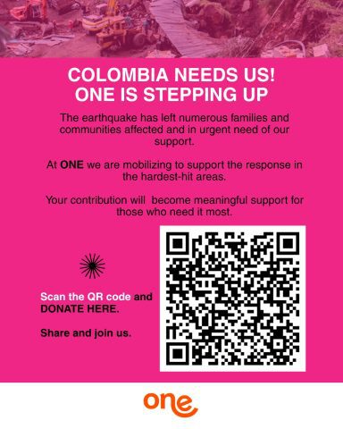
The One Foundation is mobilizing to support the response in the hardest hit areas. Click or scan the QR code.
How to help
Readers looking to support relief efforts can donate through the UNGRD‘s official channels , the One Foundation (One Inversión Social), or the Cruz Roja Colombiana (Colombian Red Cross), which coordinates emergency response nationally; its website was intermittently unreachable Monday amid the surge in traffic following the earthquake. In Medellín, the Fundación Banco Arquidiocesano de Alimentos de Medellín (Carrera 52 No. 30A-97) and Fundación Saciar (Carrera 50 No. 25-261) are collecting non-perishable food, water, rice, cooking oil, pasta, lentils, beans, canned goods, cornmeal, wheat flour, panela, powdered and UHT milk, hygiene products, diapers, and bedding for affected families. Noticias Caracol has additional donation points as they are confirmed.
Understanding the science: why a deep quake shook such a wide area
For readers unfamiliar with seismology, a few basics help explain why an earthquake this size caused damage across several cities at once, rather than concentrated destruction near a single epicenter.
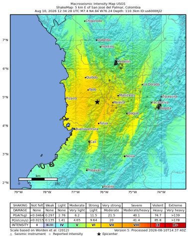
Estimated shaking intensity for the August 10, 2026, earthquake near San José del Palmar, Chocó. Image: US Geological Survey (USGS)
Earthquake magnitude measures the total energy released at the source; USGS calculated this event at 7.4 on the moment magnitude scale, the modern standard that replaced the older Richter scale for large earthquakes. Depth matters just as much as magnitude in determining what people on the surface actually feel. Most damaging earthquakes, like Ecuador’s 2016 Muisne quake or Haiti’s 2010 disaster, originate less than 20 kilometers below the surface, concentrating destructive shaking in a relatively small area near the epicenter. Monday’s earthquake originated roughly 110 kilometers down, a category seismologists call an “intermediate-depth” earthquake (any quake between 70 and 300 kilometers deep). Energy traveling that far to the surface loses some of its punch directly overhead, but it spreads shaking, typically more moderate but still potentially damaging, across a much broader region. That is why residents felt Monday’s earthquake as far as Bogotá and across three neighboring countries, even though the shaking was most intense closer to the Chocó-Valle del Cauca border.
The quake’s mechanism was primarily strike-slip faulting, meaning the two sides of the fault slid horizontally past each other, rather than one block thrusting up over the other, as happens in the shallow “megathrust” earthquakes more familiar along Chile’s or Japan’s coastlines. USGS’s analysis of the seismic waves (a “focal mechanism”) could not distinguish between two possible fault orientations, a steeply dipping fault with a mix of reverse and left-lateral motion, or a moderately dipping fault with largely right-lateral motion, but both are consistent with deformation occurring inside the Nazca plate itself as it descends beneath the South America plate along Colombia’s Pacific margin. Given the depth, USGS said the rupture likely occurred within the subducting plate rather than at the shallower boundary between the two plates.
Intermediate-depth earthquakes like this one are common along the length of the South America subduction zone and are generally attributed to bending stresses within the descending plate, distinct from the shallower interface earthquakes that produce tsunamis. Monday’s event occurred near the northernmost point where this type of intermediate-depth seismicity has historically been observed in Colombia. USGS noted that only two earthquakes of magnitude 7 or larger have occurred within 250 kilometers of Monday’s epicenter since 1950, and both were located near the coast; the region has more typically produced earthquakes below magnitude 7. USGS’s automated PAGER impact system, which generates preliminary loss estimates within hours of an earthquake to guide humanitarian response, issued an “orange” alert, its second-highest level, indicating significant casualties and widespread damage were likely; the system’s early statistical model, not a confirmed count, pointed toward hundreds of fatalities and roughly $649 million USD in economic losses, broadly in line with the toll now being confirmed on the ground.
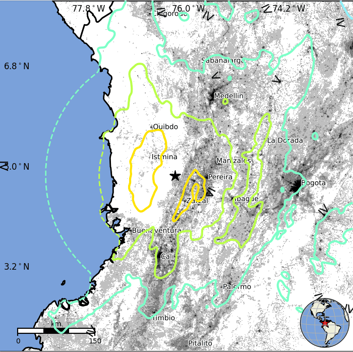
Estimated population exposed to each level of shaking intensity. Image: US Geological Survey (USGS)
A volcano already on alert nearby
The earthquake struck as Colombian authorities were already managing a separate, unrelated emergency: an orange alert at Volcán Puracé (Puracé Volcano) in the department of Cauca, roughly 150 kilometers south of Monday’s epicenter. The SGC has kept the Coconucos volcanic chain, which includes Puracé, Piocollo, and Curiquinga, under its second-highest alert level since a sharp rise in seismicity and gas emissions began around July 20, with instrumental readings in early August reaching the highest levels recorded since continuous monitoring began in 1993.
The volcano has produced six ash emissions since the afternoon of Friday, August 7, including two significant plumes, documented by residents and the SGC’s monitoring cameras, on Friday at 5:57 p.m. and Saturday at 9:12 a.m. Sulfur dioxide flux from the crater has measured around 2,100 tons per day, well above the volcano’s historical average, while ground-based carbon dioxide readings have also climbed. Natalia Contreras, the SGC official who oversees geohazard information, said the seismic activity driving the alert is dominated by fluid movement in shallow volcanic conduits, tremor and long-period earthquakes located less than a kilometer beneath the crater, rather than by rock-fracturing earthquakes, which have stayed comparatively rare and weak. It is the second time in less than eight months that Puracé has reached orange alert. The UNGRD has begun trucking water to roughly 3,000 residents in nearby communities after ash and acidic gases affected local water sources and pasture, and has prepared, but not activated, evacuation routes for the area.
Finance Colombia asked Isabella Casasbuenas, a mining engineer from Colombia’s Universidad Nacional (National University), whether Monday’s earthquake and Puracé’s unrest are connected. She explained that the same regional seismic systems and plate tectonics, ultimately driven by the Nazca plate’s subduction beneath South America, underlie both phenomena, but cautioned against inferring any direct causal link between the two without further evidence. Seismologists broadly share that caution: Monday’s rupture occurred roughly 110 kilometers underground, within the subducting Nazca plate, while the seismicity driving Puracé’s alert is occurring less than 2 kilometers beneath the volcano’s crater, in the shallow magmatic and hydrothermal system that feeds it. The two processes sit within the same broad tectonic framework but are not, on current evidence, mechanically linked events.
This is a developing story. Casualty and damage figures are preliminary and likely to change as search-and-rescue operations continue.

USGS’s ShakeMap system, which models expected shaking intensity using the Modified Mercalli Intensity (MMI) scale, estimated that roughly 1.6 million people experienced “very strong” shaking (MMI VII), nearly 8.9 million experienced “strong” shaking (MMI VI), and another 17 million experienced “moderate” shaking (MMI V) across Colombia, Ecuador, and Panama.